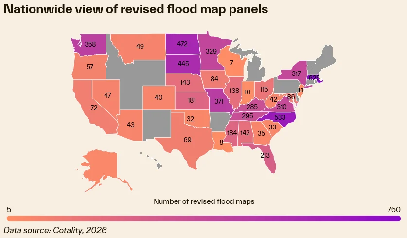
The Federal Emergency Management Agency (FEMA) has finalized updates to its national flood insurance rate maps, a regulatory shift that has resulted in thousands of residential properties being reclassified into the high-risk Special Flood Hazard Area (SFHA). According to a comprehensive alert issued this week by business intelligence firm Cotality, this reclassification mandates that homeowners in over 100 communities across 12 states secure flood insurance coverage within a 45-day window to maintain compliance with federal mortgage requirements. Failure to secure this coverage risks not only financial exposure in the event of a disaster but also potential administrative disruptions, including the forced placement of insurance by mortgage servicers, which often carries significantly higher premiums.
The Scope of the Reclassification
The updated maps reflect the evolving nature of climate risk and the improved precision of flood modeling technology. As hydrology changes and urban development alters natural drainage patterns, FEMA periodically updates its Flood Insurance Rate Maps (FIRMs). The current cycle has disproportionately affected coastal and low-lying regions, though the inclusion of inland areas—such as Ithaca, New York—demonstrates that the risk profile for flood damage is expanding beyond traditional hurricane-prone geographies.
Data provided by Cotality highlights the scale of this transition. Escambia County, Florida, leads the list with 2,344 properties newly designated within the SFHA. Other significantly affected regions include Pender County, North Carolina (678 properties), Chattanooga, Tennessee (635 properties), and the twin-impacted municipalities of Ithaca, New York, and Methuen, Massachusetts, each seeing 428 properties remapped into high-risk zones.
Chronology of Regulatory Shifts
The process of updating FEMA maps is a multi-year endeavor involving rigorous engineering studies and public review periods. However, for the average homeowner, the realization of these changes often feels abrupt. The current 45-day compliance window is a standard regulatory threshold, but it creates a significant immediate financial burden for households operating on thin margins.
Historically, the timeline for map modernization follows a series of steps:
- Discovery and Study: FEMA identifies areas where existing data is outdated or where significant land-use changes have occurred.
- Preliminary Mapping: Initial results are shared with local government officials for review and feedback.
- Public Comment Period: A formal window is opened for residents and local governments to appeal findings or provide supplementary data.
- Letter of Final Determination (LFD): Once appeals are addressed, FEMA issues an LFD, which officially sets the clock for the six-month adoption period by local communities.
- Effective Date: Following the adoption period, the new maps become the legal standard for insurance requirements.
Many homeowners only become aware of these changes when they receive correspondence from their mortgage servicers notifying them that their property is now in a mandatory flood zone. Because direct notification from federal agencies to individual property owners is not always guaranteed, there is a frequent communication gap that leaves many families unprepared for the sudden increase in escrow requirements.
Financial Implications and Mortgage Delinquency
The economic consequences of this remapping extend well beyond the cost of a premium. For many homeowners, particularly those utilizing Federal Housing Administration (FHA) loans, the addition of flood insurance to an escrow account can push the total monthly payment beyond sustainable levels. Cotality’s research indicates that for approximately 10% of homeowners, the funds required for escrow—encompassing property taxes, hazard insurance, and now mandatory flood insurance—already exceed the principal and interest portions of their mortgage payments.
This financial strain carries systemic risks for the housing market. Historical delinquency data from Gulf Coast states, including Louisiana, Mississippi, and Texas, provides a clear roadmap of what happens when environmental mandates collide with economic instability. In these regions, a strong correlation exists between the sudden spike in insurance premiums and subsequent mortgage defaults. When a homeowner’s housing costs balloon due to external factors like flood risk reclassification, the risk of foreclosure increases, which can create localized instability in the real estate market.
Expert Perspectives on Risk and Resilience
The objective behind these map updates is to align insurance coverage with current scientific data regarding flood risk. Howard Botts, chief scientist at Cotality, emphasized that while the transition is difficult for individual households, accurate data is the cornerstone of long-term community survival.
"Stability is invaluable, and having the most accurate view of risk will mean millions more homeowners are prepared when the storm inevitably arrives," Botts stated in the Cotality alert. "Preparation leads to community resilience, which can lessen the burden of recovery."
From the perspective of urban planners and emergency managers, the remapping is a necessary diagnostic tool. By identifying high-risk zones, local governments can better enforce building codes, design more resilient infrastructure, and ensure that new construction does not exacerbate the flood vulnerability of existing neighborhoods. However, the disconnect remains in how this risk is communicated to those currently living in those zones.
The Role of Mortgage Servicers and Stakeholders
There is an increasing call for mortgage lenders and servicers to play a more proactive role in the transition process. As stakeholders in the physical security of the collateral, lenders have a vested interest in ensuring that properties are adequately insured. However, they also possess the data necessary to identify these risks long before a FEMA map becomes official.
Industry analysts suggest that mortgage loan providers should move toward a model of "environmental forecasting." By assessing long-term environmental outcomes and disclosing potential flood risks to borrowers at the time of origination, lenders could prevent the "shock" effect currently experienced by homeowners. This transparency would allow families to factor in the potential for future insurance mandates when calculating the true cost of homeownership.
Broader Implications for the Real Estate Market
The reclassification of thousands of properties across 12 states is a microcosm of a larger, national trend. As climate volatility increases, the concept of a "100-year flood" is becoming increasingly obsolete, forcing federal agencies to update maps with greater frequency. This dynamic is reshaping the real estate market in several ways:
- Property Valuation: Homes newly designated as high-risk may see a stagnation or decline in resale value, as prospective buyers factor the cost of mandatory insurance into their purchase offers.
- Affordability Crisis: In markets already struggling with high interest rates and low inventory, the addition of significant annual flood insurance premiums may disqualify many first-time homebuyers from entering the market.
- Insurance Availability: In some states, the private insurance market is retreating from high-risk zones, leaving homeowners reliant on the National Flood Insurance Program (NFIP). This reliance puts further strain on a federal system that is already heavily indebted.
Navigating the Mandate
For homeowners currently facing the 45-day deadline, the immediate priority is to consult with their insurance agent to secure a policy that meets FEMA requirements. It is also essential to verify if the property qualifies for a "Grandfathering" rule, which can sometimes allow a property to be rated based on its previous, lower-risk designation if it was built in compliance with the maps in effect at the time of construction.
Furthermore, homeowners are encouraged to contact their local floodplain administrator. These municipal officials have access to the specific maps and engineering reports that led to the reclassification and can provide clarity on whether the property is fully or partially within the SFHA.
Conclusion
The latest FEMA map updates underscore the intensifying intersection of environmental risk and personal finance. While the transition to more accurate flood mapping is essential for the long-term safety of American communities, the current implementation process highlights a critical need for better communication and financial support for vulnerable homeowners. As climate risks continue to evolve, the resilience of the U.S. housing market will depend heavily on the ability of stakeholders—from federal regulators to private lenders—to ensure that risk assessment is transparent, timely, and integrated into the broader conversation about sustainable homeownership. Moving forward, the focus must shift from reactive compliance to proactive risk management to ensure that homeowners are not left in the dark regarding the true costs and hazards associated with their properties.