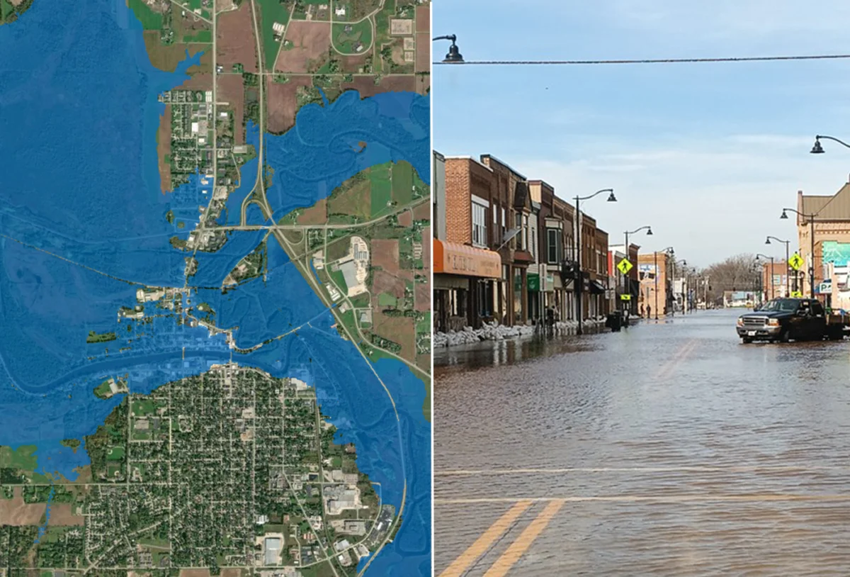
The National Oceanic and Atmospheric Administration’s (NOAA) National Weather Service (NWS) has reached a significant milestone in meteorological and hydrological monitoring, announcing the full-scale deployment of its Flood Inundation Mapping (FIM) tool. Originally covering only 60 percent of the nation, the platform now provides comprehensive coverage across the entire continental United States, along with critical U.S. territories and Hawaii. This expansion represents a paradigm shift in how emergency management agencies, local governments, and the public visualize flood risks, moving beyond abstract river gauge measurements to hyper-local, neighborhood-level visual data.
The FIM tool operates by synthesizing complex hydrological data, including model-forecasted river flows and real-time environmental conditions. By processing these inputs, the system generates high-resolution maps that estimate exactly which land areas will be submerged under water. For residents in flood-prone regions, this transition from numerical data—such as "14-foot crest heights"—to visual inundation maps provides an intuitive understanding of danger. It allows individuals to see if their specific property, primary commute route, or local infrastructure is in the path of rising waters, facilitating more informed evacuation and mitigation decisions.
A Chronology of Technological Evolution
The development of the FIM tool is part of a broader, decade-long effort by NOAA’s Office of Water Prediction (OWP) to modernize the nation’s flood forecasting infrastructure. The project’s trajectory has been characterized by rapid scaling and continuous refinement of the underlying computational models.
In 2023, the NWS first unveiled the experimental iteration of FIM, which at the time covered a modest 10 percent of the U.S. population. This initial launch was designed to test the efficacy of the visualization software against historical flood data and gauge performance. Following successful pilot programs, the NWS aggressively scaled the tool, reaching 60 percent coverage by 2025. The rapid expansion to nearly 100 percent in such a short timeframe reflects a significant investment in high-performance computing and the integration of the National Water Model, which provides the backbone for these simulations.
While the current milestone covers the vast majority of the U.S. population and geography, the NWS has noted that the rollout is an iterative process. Certain regions, including northern and western Alaska, Guam, the Northern Mariana Islands, and American Samoa, are not yet integrated into this specific FIM framework. The NWS has signaled that technical and data-collection hurdles in these remote or geographically isolated areas remain a priority for future integration phases.
Data-Driven Flood Mitigation
The implications of this tool extend far beyond general public awareness. By mapping 3.3 million river miles, the FIM platform provides a standardized dataset for emergency responders. Historically, flood warnings were often relayed through standardized NWS text alerts that described river stages at specific gauging stations. While accurate, these reports often lacked the granular detail required for effective tactical decision-making at the municipal level.
The new FIM data, now available on the National Water Prediction Service website, allows for integration into Geographic Information Systems (GIS). This enables city planners and emergency managers to overlay flood risk maps with critical infrastructure data—such as the location of power substations, hospitals, fire stations, and vulnerable transportation networks. By anticipating which roads will be rendered impassable, emergency services can pre-position resources and optimize evacuation routes days before a flood event occurs.
Supporting data from the Federal Emergency Management Agency (FEMA) underscores the necessity of this advancement. According to national hazard statistics, flooding remains the most frequent and costly natural disaster in the United States, accounting for billions of dollars in property damage annually. As climate patterns shift and extreme precipitation events become more frequent, the ability to visualize the reach of a flood has become a cornerstone of the nation’s resilience strategy.
Official Perspectives and Institutional Significance
The announcement was met with strong support from leadership within NOAA and the NWS, who view the tool as a cornerstone of the agency’s "Weather-Ready Nation" initiative.
"Inundation maps are a critical tool for assessing the impacts of flooding," stated NOAA Administrator Neil Jacobs, Ph.D. "NOAA prioritized expanding FIM to ensure that nearly every American can access detailed information beyond the expected river crest height. This is about providing the right information at the right time to save lives and protect property."
The sentiment was echoed by NWS Director Ken Graham, who emphasized the tool’s utility in high-stress operational environments. "FIM has been a game changer when briefing emergency managers, first responders, and communities facing flood risk," Graham noted. "When you are in the middle of a flooding event, you need to know exactly where the water is going to go. This tool provides that clarity in a way that was previously unavailable to the general public."
The Office of Water Prediction, which serves as the primary engine behind these models, has also highlighted the importance of inter-agency cooperation. The success of the FIM project relies on a complex network of stream gauges, satellite imagery, and soil moisture sensors maintained by various state and federal partners, including the U.S. Geological Survey (USGS) and the U.S. Army Corps of Engineers.
Broader Impact and Future Implications
The expansion of FIM to cover the southeastern U.S. coast, Florida, the Great Lakes region, New England, the Rocky Mountains, the Dakotas, and western Nebraska fills critical gaps in the national coverage map. These regions have historically faced diverse flood threats, ranging from storm surges and tropical cyclone-induced flooding in the Southeast to rapid snowmelt and ice-jam flooding in the Northern Plains.
By providing these maps in near-real-time, the NWS is effectively democratizing access to technical meteorological data. The availability of multiple file types and GIS-compatible formats means that local news outlets, mobile app developers, and private sector risk analysts can integrate this information into their own platforms. This creates a redundant system of information dissemination, ensuring that even if one channel of communication is compromised, the public remains informed.
However, experts caution that while FIM is a powerful tool, it is not a replacement for traditional safety protocols. The maps provide estimates based on current hydrological models and are subject to the inherent uncertainties of weather forecasting. As such, they are intended to complement, not supersede, the official watches and warnings issued by local NWS weather forecast offices.
Furthermore, the integration of these maps into local zoning and insurance policies could have long-term societal impacts. As property owners gain a clearer understanding of their flood risk, there may be increased pressure for improved land-use planning, the construction of more resilient infrastructure, and a re-evaluation of flood insurance risk ratings.
Conclusion
The completion of the national FIM rollout marks a turning point in how the United States manages its relationship with one of nature’s most destructive forces. By shifting the focus from the height of a river to the footprint of the water, the National Weather Service has provided a vital asset for public safety. While the tool continues to evolve, its reach across the continental United States establishes a new standard for transparency and accessibility in federal emergency management. As the nation moves into an era of increasing weather volatility, tools like FIM will prove essential in minimizing the human and economic toll of future flood disasters. The commitment to expanding this coverage to the remaining territories remains a clear signal that the NWS intends to continue this trajectory of technological advancement and comprehensive national service.