
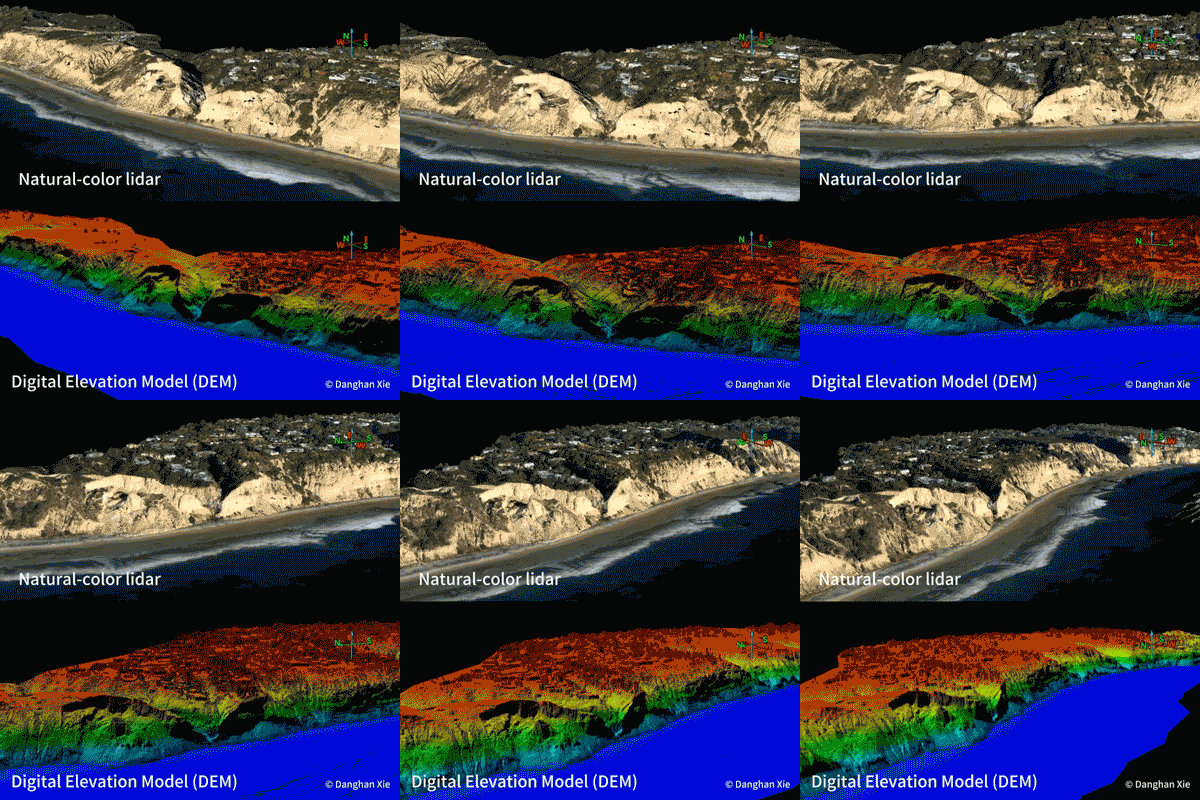
A landmark study conducted by researchers at UC San Diego’s Scripps Institution of Oceanography has unveiled a startling transformation of the California coastline, documenting a rate of erosion that poses profound challenges to public safety and infrastructure management. By analyzing high-resolution aerial lidar surveys captured between 2016 and 2023, scientists have quantified the loss of cliff material at a staggering scale: roughly 800 dump-truck loads of rock and sediment for every single yard of shoreline. This data, recently published in the International Journal of Applied Earth Observation and Geoinformation, marks the most comprehensive assessment of California’s shifting coastal geology to date, highlighting a phenomenon that is both highly volatile and unevenly distributed across the state’s 840-mile coastline.
A Shifting Landscape: The Scale of Erosion
Approximately 70% of California’s iconic coastline is defined by coastal cliffs, natural barriers that are increasingly succumbing to the combined forces of geological instability and environmental stressors. The research team, led by coastal geomorphologist Danghan Xie—now an assistant professor at the University of Maryland—and Scripps researcher Adam Young, found that 65% of the state’s cliffs exhibited measurable changes beyond established study thresholds during the seven-year observation period.
The study serves as a critical update to previous data, much of which was over a decade old and failed to account for recent shifts in weather patterns and sea-level variability. The findings reveal that erosion is not a uniform process; instead, it occurs in concentrated "hotspots." While some areas remain relatively stable, others are retreating at rates that defy historical averages. In Northern and Central California, researchers documented specific zones experiencing retreat exceeding 30 feet per year, with extreme outliers reaching more than 70 feet annually.
Chronology of a Disappearing Coast
To understand the severity of these changes, one must consider the timeline of the data collection. The Scripps team utilized cutting-edge lidar technology—a remote sensing method that uses light in the form of a pulsed laser to measure distances—to create precise 3D maps of the cliffs. By comparing surveys taken in 2016 against those from 2023, the researchers were able to create a high-fidelity "before and after" snapshot of the state’s edge.
The Lost Coast Headlands in Humboldt County stand as a primary example of this rapid geomorphological change. During the study period, a single catastrophic landslide event in this area involved the movement of more than 1.4 million cubic yards of rock and soil. According to Adam Young, the principal investigator of the project, a retreat rate of 70 feet per year is difficult to conceptualize in human terms, but he notes that over the seven-year duration of the study, that movement equates to a loss of land greater than the length of a football field.
Other regions identified as high-risk zones, with cliff-top retreat rates exceeding 10 feet per year, include:
- The King Range and Redwood National Park
- Point Reyes National Seashore
- Big Sur
- The coastline near Martins Beach
- Vandenberg Space Force Base
- El Capitan State Beach
- Palos Verdes
The Geomorphological Reality of Unstable Cliffs
The implications of these findings extend far beyond academic interest in geology. The cliffs that define the California coastline are inherently unstable, functioning as dynamic systems that are constantly in a state of flux. "The cliffs are not stable," explains Dr. Xie. "They erode and collapse over time. We’ve seen many sad news stories about fatal cliff landslides. It’s unpredictable and a significant hazard to the coastal community."
For beachgoers, the risk is immediate. Cliff collapses are often sudden, and because the structural integrity of the rock can be compromised by factors invisible to the naked eye—such as internal fractures or water saturation—there is often little warning before a section of the bluff gives way. The study underscores the necessity of public awareness, as these geographical hazards present a persistent danger to those recreating at the base of these cliffs.
Economic and Infrastructure Implications
Beyond the immediate threat to human life, the findings carry significant weight for state planners, civil engineers, and property owners. Much of California’s critical infrastructure—including state highways, rail lines, wastewater treatment facilities, and public parks—is situated precariously near the edge of these retreating cliffs.
The retreat of 70 feet per year in some locations represents a direct economic threat. Coastal real estate, which commands some of the highest valuations in the world, faces an existential crisis as the buffer between the built environment and the Pacific Ocean narrows. Furthermore, the loss of sediment from these cliffs is a double-edged sword; while the erosion is destructive, the material eventually feeds the beaches below. However, the current rate of retreat suggests that the state’s coastal management strategies must shift from reactive stabilization to proactive planning.
A New Framework for Monitoring
Recognizing the gravity of the situation, the Scripps team has launched the California Coastal Cliff Erosion Viewer. This public-facing web portal aggregates the lidar data, allowing citizens and policymakers to visualize the erosion patterns in their own regions. The program is currently designed to collect lidar imagery twice annually, providing a level of temporal resolution that was previously unavailable.
"A detailed time series of cliff changes does not exist in many areas, and this makes it hard to build better predictive models," says Dr. Young. "This project creates updated, routine, systematic data for improved coastal planning." By moving toward a standardized, statewide monitoring system, California is positioning itself to better anticipate where and when future collapses might occur.
Challenges to Future Research
Despite the success of the current study, the project faces a significant hurdle: funding. The current grant for this comprehensive monitoring program is scheduled to expire in 2027. Researchers emphasize that the value of this data is cumulative; the longer the record, the more accurate the predictive models become. Without sustained financial support, the ability of the state to monitor these critical geological changes will revert to fragmented, sporadic surveys, leaving coastal communities vulnerable to the element of surprise.
The research team, which includes contributors such as Luc Lenain and Hironori Matsumoto of Scripps, alongside Zuzanna Swirad from the Polish Academy of Sciences, has provided a roadmap for how the state can manage its coastal resources. Their work highlights that while California’s coast is inherently dynamic, the acceleration of these changes is a clear call to action for environmental policy.
Conclusion: Preparing for an Evolving Shoreline
The Scripps Institution of Oceanography study provides a sobering look at the rate at which California is physically losing its ground to the ocean. As the state grapples with the dual pressures of climate change and geological instability, the integration of high-resolution lidar mapping into public policy is no longer an option, but a necessity.
The data confirms that the "California Dream" of living on the edge of the continent is becoming increasingly complex. As the cliffs continue to yield to the Pacific, the priority remains the protection of public life and the preservation of the infrastructure that allows millions to enjoy the coastline. Through the systematic efforts of researchers like Young and Xie, California is at least now equipped with the data necessary to understand the pace of the change, even if the challenge of mitigating it remains one of the most significant environmental hurdles of the century. As 2027 approaches, the question for state legislators will be whether the momentum generated by this vital research will be maintained, or if the state will allow its primary tool for coastal vigilance to drift into the past.