
The state of Arizona experienced a rare and significant meteorological event on October 21, 2026, as a powerful storm system spawned two separate EF-1 tornadoes. According to the National Weather Service (NWS) forecast office in Flagstaff, these tornadoes caused extensive property damage, widespread vegetation destruction, and triggered emergency responses across the Bradshaw Mountains and the Heber-Overgaard region. While Arizona is historically less susceptible to the intense tornadic activity seen in the Great Plains, this event serves as a stark reminder of the potential for severe weather in the high-country regions of the Southwest.
Chronology of the October 21 Severe Weather Event
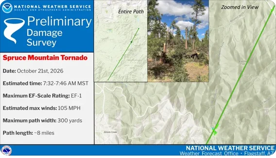
The severe weather began early on the morning of October 21, when atmospheric conditions became favorable for rotation within a passing storm cell. The first confirmed tornado touched down near Lookout Mountain. Meteorological data indicates that the tornado formed during the morning hours, tracking in a north-northeasterly direction. It remained on the ground for approximately eight miles, carving a path of destruction through the rugged terrain of the Bradshaw Mountains.
The storm’s path took it directly across Spruce Mountain and over Walker Road. The impact in this area was characterized primarily by significant forest damage, as the vortex snapped and uprooted large ponderosa pines. The NWS survey team later determined the intensity of this event reached EF-1 status, with peak wind speeds estimated at approximately 105 mph.
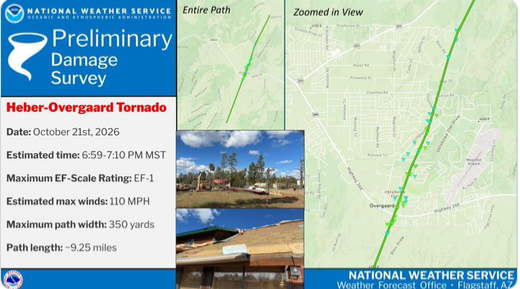
As the day progressed, the storm system moved toward the eastern regions of the state. By Wednesday evening, a second, more destructive tornado formed south of Heber-Overgaard. This system proved to be more disruptive to human infrastructure. Traveling north, the tornado crossed Highway 260 and moved directly through the town of Heber-Overgaard. It continued its trek for over nine miles before finally dissipating near Highway 277. The evening event was slightly more powerful, with peak wind speeds estimated at 110 mph, placing it at the high end of the EF-1 spectrum.
Detailed Damage Assessment and Meteorological Data
The NWS Flagstaff office conducted extensive ground surveys in the days following the event to verify the wind speeds and paths of both tornadoes. The Enhanced Fujita (EF) Scale, which assesses wind damage on a scale of 0 to 5, was used to categorize both incidents.
The Heber-Overgaard tornado left the most significant mark on local infrastructure. Field reports confirmed that the southern side of Highway 260 and the central portions of Overgaard suffered the brunt of the impact. Multiple residential homes and commercial structures reported structural damage, ranging from roof failures to debris-related wall damage. Beyond the structural impact, the sheer force of the 110 mph winds decimated local vegetation, leaving behind a trail of snapped timber that hindered initial cleanup efforts.
The Lookout Mountain tornado, while having a slightly lower peak wind speed of 105 mph, demonstrated the unique hazards posed by mountainous topography. The damage was most evident in the swaths of destroyed forestland. Because the area is sparsely populated, the structural impact was lower, but the ecological footprint of the tornado was substantial.
Official Responses and Public Safety
Local authorities and emergency responders mobilized immediately following the reports of damage. In Heber-Overgaard, where the tornado impacted populated residential zones, emergency crews worked through the night to clear roadways and ensure that residents were safe. Officials confirmed one non-life-threatening injury resulting from the storm. This relatively low casualty rate is largely attributed to the timing of the storm and the public’s adherence to weather alerts issued throughout the day.
The National Weather Service played a critical role in mitigating the impact of these events. By issuing timely warnings, the NWS allowed residents to seek shelter before the tornadoes reached their peak intensity. Meteorologists in the Flagstaff office noted that while these events were anomalous, the environmental conditions—specifically the combination of wind shear and moisture influx—created a localized environment conducive to cyclonic activity.
Contextualizing Arizona Tornadoes
To understand the rarity of the October 21 event, one must look at the broader climatological context of Arizona. Tornadoes in the state are generally weak, often classified as "landspouts" or short-lived EF-0 events. The occurrence of two confirmed EF-1 tornadoes in a single day is a noteworthy deviation from the norm.
The EF Scale, utilized by the NWS, provides a standardized method for estimating wind speeds based on damage:
- EF0 (65–85 mph): Light damage; shingles removed, branches broken.
- EF1 (86–110 mph): Moderate damage; mobile homes overturned, roofs stripped.
- EF2 (111–135 mph): Considerable damage; roofs torn off well-constructed houses.
- EF3 (136–165 mph): Severe damage; entire stories of homes destroyed.
- EF4 (166–200 mph): Devastating damage; well-constructed houses leveled.
- EF5 (>200 mph): Incredible damage; strong-framed houses lifted off foundations.
By reaching the 105 mph and 110 mph marks, both tornadoes fell firmly into the EF-1 category. This signifies a level of intensity capable of causing significant structural failure, which was clearly evidenced in the damage to the homes and commercial buildings in the Heber-Overgaard area.
Broader Implications and Future Preparedness
The October 21, 2026, event highlights the importance of maintaining robust weather-monitoring infrastructure in high-altitude regions. Historically, mountainous terrain was thought to be somewhat protective against tornadic development, but modern meteorological modeling has increasingly shown that complex terrain can actually focus and enhance wind rotation under the right atmospheric conditions.
For residents in rural Arizona communities, this event serves as a prompt to review emergency preparedness plans. Unlike the central United States, where "tornado season" is a well-understood concept, Arizona’s severe weather risks are often sporadic and tied to monsoon remnants or mid-latitude cyclones. The lack of a frequent tornado history can sometimes lead to public complacency; however, the damage sustained in this event proves that even in regions accustomed to clear skies, the potential for destructive wind events remains a constant threat.
Moving forward, the NWS Flagstaff office is expected to continue analyzing the data collected from the October 21 storms. This information will be integrated into future forecasting models to improve the accuracy of warning systems for high-country residents. Furthermore, the event has prompted discussions among local government leaders regarding the strengthening of building codes, particularly in regions prone to high-wind events.
Conclusion
The dual EF-1 tornadoes that impacted Arizona on October 21, 2026, represent a significant, albeit isolated, weather event. The resilience of the affected communities, combined with the effective communication of the National Weather Service, ensured that the event did not result in a loss of life. As the recovery process concludes and the debris is cleared, the lessons learned from this incident will undoubtedly contribute to a more prepared and weather-aware Arizona. The event remains a documented milestone in the state’s meteorological history, underscoring that no region is entirely immune to the atmospheric volatility of the Earth’s climate system.