
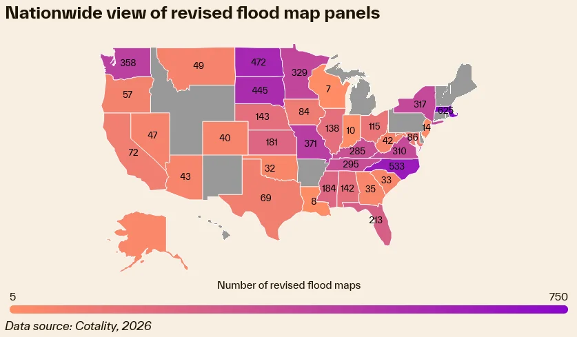
The Federal Emergency Management Agency (FEMA) has finalized revisions to its flood insurance rate maps (FIRMs), a move that carries immediate and significant financial implications for property owners across more than 100 communities. According to a recent alert from business intelligence provider Cotality, thousands of residential properties previously categorized as low-to-moderate risk have been reclassified into the high-risk Special Flood Hazard Area (SFHA). For homeowners in these designated zones, the reclassification is not merely a technical adjustment; it triggers a federal mandate requiring the maintenance of flood insurance coverage. Compliance must be achieved within 45 days of the formal notification to avoid mortgage defaults or administrative actions by lenders.
The Geography of Risk: Impacted Regions
The reclassification spans a diverse geographic footprint, reflecting the evolving nature of climate risk in the United States. While the updates affect 12 states, the concentration of newly mapped properties is particularly heavy in coastal and riverine areas. Escambia County, Florida, leads the list with 2,344 properties now situated within the SFHA. Pender County, North Carolina, and Chattanooga, Tennessee, also report significant numbers of impacted homes, with 678 and 635 properties affected, respectively. Ithaca, New York, and Methuen, Massachusetts, round out the top five, each reporting 428 properties newly subject to the mandate.
These data points illustrate a shift in how federal agencies view flood risk. Historically, flood maps were static documents, updated infrequently. However, in response to rising sea levels, more frequent extreme precipitation events, and urban development that alters drainage patterns, FEMA has accelerated its map modernization program. This process relies on advanced hydrological modeling and satellite imagery, resulting in more granular—and often more expansive—risk assessments.
Chronology of the Reclassification Process
The process of updating FIRMs is a multi-year endeavor involving rigorous engineering studies, public comment periods, and local government cooperation. For the communities impacted in 2026, the current alert is the final stage of a process that likely began years ago.
- Initial Assessment: FEMA, often in partnership with state agencies, conducts a flood risk study using updated topographical data and historical climate patterns.
- Preliminary Mapping: The agency releases preliminary maps for public review. During this window, local stakeholders and homeowners have the opportunity to challenge the data or provide supplemental information.
- Formal Adoption: Following the resolution of appeals, the maps are finalized, and a Letter of Final Determination (LFD) is issued to the community leaders.
- The Compliance Clock: Once the maps become effective, mortgage lenders are legally required to ensure that all properties within the SFHA carry flood insurance as a condition of the loan. This is the 45-day window that currently challenges thousands of families.
Financial Strain on Vulnerable Borrowers
The timing of these updates coincides with a period of significant economic pressure on American homeowners. Cotality’s research highlights a concerning trend regarding escrow accounts. For approximately 10% of homeowners, the funds required for property taxes and hazard insurance—which are held in escrow—already exceed the monthly principal and interest payments on their mortgages. The addition of a mandatory flood insurance policy, which can range from several hundred to several thousand dollars annually depending on the risk level and property value, creates a "cost of ownership" crisis for lower-income households.
This is particularly acute for those utilizing Federal Housing Administration (FHA) loans. These borrowers often have lower down payments and tighter debt-to-income ratios. An unexpected spike in mandatory insurance premiums can disrupt household budgets, potentially leading to delinquency. Furthermore, the lack of a federal mandate requiring direct notification to homeowners—meaning that information is often funneled through mortgage servicers or municipal offices—leaves many residents unaware of their new risk status until a letter arrives from their lender demanding proof of insurance.
Historical Precedents and Market Implications
Historical delinquency data from Gulf Coast states—including Louisiana, Mississippi, and Texas—suggests a direct correlation between environmental reclassification and mortgage instability. When insurance premiums increase abruptly, or when new mandates are imposed, the likelihood of default rises, particularly in areas where property values are already under pressure from environmental degradation.
"Stability is invaluable, and having the most accurate view of risk will mean millions more homeowners are prepared when the storm inevitably arrives," says Howard Botts, chief scientist at Cotality. "Preparation leads to community resilience, which can lessen the burden of recovery."
While Botts emphasizes the long-term benefits of risk awareness, the immediate transition period remains fraught with friction. Mortgage lenders are tasked with the difficult job of identifying impacted properties and notifying borrowers. However, if the communication flow is inefficient, homeowners are often left with a narrow window to secure affordable coverage. The National Flood Insurance Program (NFIP) is the primary provider for many of these properties, but private flood insurance options have grown in recent years, offering potential alternatives for those who find the NFIP premiums prohibitive.
Broader Economic and Structural Implications
The implications of these map updates extend beyond the individual homeowner. For the mortgage industry, the reclassification of thousands of properties necessitates a re-evaluation of risk portfolios. Financial institutions must now account for the increased likelihood of property damage in their collateral assessment. This could lead to tighter lending standards in newly mapped SFHAs, potentially impacting home equity and property values in the long term.
Furthermore, the lack of "grandfathering" protections—which vary depending on the specific state and community—means that even homeowners who have lived in their residences for decades without a flood event are now subject to the same requirements as new buyers. This creates a psychological and financial shock that ripples through the local real estate market.
Real estate analysts suggest that as FEMA continues to update its maps to reflect current climate realities, the "hidden" costs of homeownership will become increasingly transparent. This transparency is necessary for long-term sustainability but requires a coordinated response from policymakers. Without subsidies or mitigation grants for low-income homeowners to install flood-resistant measures, the mandate may inadvertently price many residents out of their own homes.
Official Responses and the Path Forward
While FEMA has not issued a blanket response to the specific Cotality alert, the agency has consistently maintained that accurate mapping is the cornerstone of disaster risk reduction. The agency’s "Risk Rating 2.0" initiative, which transformed how flood insurance premiums are calculated by accounting for individual property characteristics rather than just zone locations, was intended to make insurance more equitable. However, for those pushed into the SFHA, the requirement for insurance remains absolute.
Community leaders in the most heavily impacted areas, such as Escambia County and Chattanooga, are now faced with the task of disseminating information and helping residents understand their mitigation options. Elevation certificates and localized drainage improvements are two primary methods by which homeowners can potentially lower their insurance premiums, but these require significant upfront capital—a resource that many affected households currently lack.
As the 45-day window closes for the latest cohort of affected homeowners, the focus is shifting toward long-term adaptation. The confluence of rising insurance costs, updated climate data, and the tightening of lending requirements indicates that the American housing market is undergoing a fundamental shift. For stakeholders—including mortgage loan providers, local governments, and the homeowners themselves—the priority must be the integration of environmental risk assessment into the very fabric of property ownership. Ensuring that homeowners are not "left in the dark" is no longer just a matter of customer service; it is an essential component of national economic and social stability.