
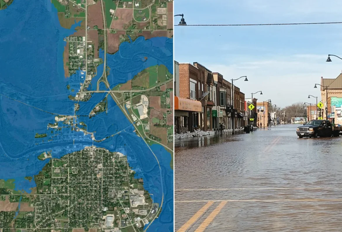
The National Oceanic and Atmospheric Administration’s (NOAA) National Weather Service (NWS) has reached a significant milestone in national disaster preparedness by expanding its Flood Inundation Mapping (FIM) tool to cover 100% of the continental United States. This technological leap provides emergency managers, local officials, and the general public with hyper-local, real-time visualizations of potential flood zones, moving beyond traditional, abstract river gauge measurements to provide a tangible look at how rising waters will interact with specific neighborhoods, roads, and critical infrastructure.
The FIM system works by integrating sophisticated hydrological modeling with high-resolution topographical data. By analyzing forecast river flows alongside current ground conditions, the tool generates detailed maps that simulate where water will spread in the days following a flood warning. This shift from "crest height" reporting—which often leaves residents guessing about the actual geographical impact—to "impact-based" mapping is expected to significantly improve the accuracy of evacuation orders and the efficiency of resource allocation during severe weather events.
A Rapid Evolution: From Pilot Program to National Standard
The path to universal coverage has been marked by rapid scaling and intense technical refinement. When the NWS first unveiled the FIM initiative in 2023, it was a limited pilot program reaching only 10% of the U.S. population. The project’s objective was to demonstrate that high-fidelity mapping could be automated and scaled across diverse geographic terrains, ranging from the flat floodplains of the Midwest to the complex river networks of the Appalachian Mountains.
By 2025, the program had expanded its reach to 60% of the country, proving the efficacy of the Office of Water Prediction’s (OWP) modeling frameworks. The latest expansion, which brings coverage to nearly every resident in the contiguous United States, represents the culmination of a multi-year effort to integrate 3.3 million river miles into a single, accessible digital interface. While the current rollout provides comprehensive coverage for the Lower 48, the NWS notes that work remains to integrate remote areas, including northern and western Alaska, as well as specific U.S. territories such as Guam, the Northern Mariana Islands, and American Samoa.
The Technical Framework of FIM
The strength of the FIM tool lies in its accessibility and its multi-layered data approach. The National Water Prediction Service (NWPS) website now serves as the primary portal for this information, offering near-real-time updates that allow users to view flooding potential across various timelines.
For the Lower 48 states and parts of south-central Alaska, the tool provides four distinct versions of inundation mapping. These versions allow for different levels of granularity, depending on the availability of high-resolution elevation data and the complexity of local river morphology. In regions like Hawaii, Puerto Rico, and the U.S. Virgin Islands, the NWS has tailored the service to account for the unique volcanic and mountainous terrain, which often causes "flashier" flooding events that differ significantly from the slow-rise flooding typically seen in major river basins.
The data is provided in multiple formats, including GIS-compatible files, which allow emergency management agencies to overlay the flood models onto their own internal maps. This integration is crucial for first responders, who can now visualize which specific bridges might be submerged or which evacuation routes could be severed by rising waters long before the water reaches the street level.
Official Perspectives on Flood Risk Mitigation
The expansion of FIM has been met with significant praise from federal officials and disaster response experts. Dr. Neil Jacobs, former NOAA Administrator, emphasized the shift in paradigm that this technology represents. "Inundation maps are a critical tool for assessing the impacts of flooding," Jacobs noted. "NOAA prioritized expanding FIM to ensure that nearly every American can access detailed information beyond the expected river crest height. We are no longer just telling people how high the water will go; we are showing them exactly what that means for their front doors and their communities."
National Weather Service Director Ken Graham echoed this sentiment, highlighting the utility of the tool in high-pressure decision-making environments. "FIM has been a game changer when briefing emergency managers, first responders, and communities facing flood risk," Graham stated. By providing a common operating picture, the NWS is reducing the "interpretive gap" that often exists between a scientific forecast and an actionable emergency plan. When decision-makers can see a map rather than a spreadsheet of numbers, the urgency and the specific requirements of a flood event become immediately apparent.
Implications for Public Safety and Infrastructure
The implications of this nationwide rollout are profound, particularly in the context of a changing climate. As extreme precipitation events become more frequent and intense, the historical data that once dictated flood zone planning is becoming less reliable. Dynamic tools like FIM allow for a more agile response to these shifting patterns.
Better Informed Public Decisions
For the average citizen, the ability to access these maps means better situational awareness. Residents can visit the NWPS website to see if their property or primary commute route is within a projected inundation zone. This democratized access to data allows individuals to make proactive decisions about securing property or evacuating early, potentially reducing the number of water rescues required during major events.
Optimized Emergency Response
Emergency management agencies are the primary beneficiaries of this technology. Historically, during a flood, responders often had to conduct "ground-truthing"—physically driving or flying over areas to see if water had reached critical points. With FIM, this reconnaissance can be performed virtually. Agencies can stage search-and-rescue teams, sandbagging operations, and utility repair crews in locations that the models predict will be most affected, effectively putting resources where they are needed before the flooding reaches its peak.
Long-Term Urban Planning
Beyond immediate disaster response, the data generated by the FIM program provides a wealth of information for urban planners and civil engineers. By analyzing where the models consistently predict inundation, municipalities can identify high-risk areas that may require long-term infrastructure improvements, such as improved drainage systems, elevated roadways, or the restoration of natural wetlands to act as flood buffers.
Challenges and Future Horizons
While the current 100% coverage milestone is a monumental achievement, the NWS and the Office of Water Prediction are already looking toward the future. The existing models are constantly being refined as better, more granular elevation data becomes available. As LiDAR (Light Detection and Ranging) mapping technology improves, the accuracy of the inundation projections is expected to increase, allowing for even tighter predictions in complex urban environments where a difference of a few inches in elevation can determine whether a basement floods.
Furthermore, the expansion into the remaining U.S. territories and the more remote reaches of Alaska remains a high priority. These areas often face unique environmental challenges, including permafrost melt and complex tropical storm dynamics, which require specialized modeling techniques distinct from those used in the continental United States.
Conclusion
The successful deployment of the Flood Inundation Mapping tool across the contiguous United States represents a new era in hydrological forecasting. By translating complex scientific data into visual, neighborhood-scale information, NOAA and the National Weather Service have equipped the nation with a vital tool for resilience. In an era where flood risk is an increasingly common reality for millions of Americans, the ability to visualize, anticipate, and respond to rising waters with precision is not just a technical achievement—it is a cornerstone of modern public safety. As the system continues to evolve, its integration into the daily operations of emergency services will undoubtedly save lives and reduce the economic burden of flooding, proving that the most effective way to manage a disaster is to see it coming.
