
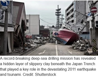
In a landmark study that redefines our understanding of plate tectonics and seismic risk, an international team of scientists has identified a hidden geological "Achilles’ heel" beneath the Pacific Ocean floor. This discovery explains why the 2011 Tōhoku-Oki earthquake in Japan reached such catastrophic proportions. By drilling to record-breaking depths into the Japan Trench, researchers have uncovered a thin, extraordinarily slippery layer of ancient pelagic clay. This microscopic layer acted as a lubricant, allowing the tectonic rupture to propagate all the way to the seafloor, displacing massive volumes of water and triggering the devastating tsunami that claimed nearly 20,000 lives.
The research, led by Northern Arizona University (NAU) in collaboration with more than a dozen international institutions, was recently published in the journal Science. The findings suggest that the presence of this specific type of sediment may be a primary indicator of whether a subduction zone is capable of producing "megathrust" events—earthquakes of magnitude 9.0 or higher that generate ocean-crossing tsunamis.
The Mechanics of a Megathrust Disaster
The March 11, 2011, earthquake is remembered as one of the most powerful seismic events in recorded history. While Japan is a nation prepared for frequent tremors, the scale of the 2011 event defied existing geological models. Most large earthquakes originate deep within the Earth’s crust, where pressure and heat create the necessary conditions for massive energy release. In a typical subduction zone, the friction between the overriding plate and the subducting plate prevents the rupture from reaching the shallowest parts of the seafloor.
However, the 2011 rupture behaved differently. It began approximately 15 miles below the seafloor but, instead of dissipating as it moved upward, it accelerated. The fault broke all the way to the ocean bottom in the Japan Trench. This caused a horizontal shift of the seafloor by an incredible 130 to 200 feet.
"That’s equivalent to the entire area between Los Angeles and San Francisco moving 130 to 200 feet in just six minutes," said Christine Regalla, an associate professor in NAU’s School of Earth and Sustainability and a co-author of the study. "We’ve never seen anything like that in the time we’ve been observing earthquakes. Based on what we understood, we didn’t think that could happen."
This massive displacement of the seabed acted like a giant paddle, pushing the entire column of the Pacific Ocean upward and outward, creating the wall of water that slammed into the Tōhoku coastline.
The Role of Pelagic Clay: A Natural Tear Line
The key to this unprecedented movement lay in a 100-foot-thick layer of pelagic clay buried deep within the trench. Pelagic clay is a fine-grained sediment formed over millions of years as microscopic particles and volcanic ash slowly settle to the ocean floor. Under the immense pressure of the subduction zone, this clay becomes exceptionally soft and slippery.
The research team found that this clay layer is sandwiched between much harder rock formations. When the earthquake began, the energy followed the path of least resistance—this clay layer. It functioned effectively as a "tear line," similar to the perforated edge of a piece of paper, concentrating the fault’s movement along a narrow, low-friction path.
"At the Japan Trench, the geologic layering basically predetermines where the fault will form," explained study co-author Patrick Fulton, an associate professor at Cornell University. "It becomes an extremely focused, extremely weak surface, which makes it easier for ruptures to propagate all the way to the seafloor."
Record-Breaking Scientific Achievement
The discovery was made possible by the Deep Sea Drilling Vessel (D/V) Chikyū, which performed the deepest scientific ocean drilling project in history. To reach the fault zone, the team had to lower a drill string through 23,000 feet of water and then drill an additional 2,700 feet into the seafloor, reaching a total depth of approximately 26,000 feet.
This feat, recognized by Guinness World Records, allowed scientists to retrieve core samples from the actual plate boundary where the 2011 slip occurred. Analyzing these samples provided the first direct evidence of the clay’s physical properties. The team used specialized friction-testing equipment to simulate the high-speed movement of an earthquake, confirming that the clay loses nearly all its frictional strength when moved rapidly, effectively becoming a liquid-like lubricant.
Chronology of the Discovery and Research
The path to this discovery began in the immediate aftermath of the 2011 disaster:
- March 11, 2011: The Magnitude 9.1 Tōhoku-Oki earthquake strikes, followed by a tsunami with wave heights reaching 130 feet in some areas.
- 2012: The Japan Trench Fast Drilling Project (JFAST) begins. Scientists use the D/V Chikyū to install temperature sensors and retrieve initial samples from the fault zone to measure the residual heat generated by the friction of the earthquake.
- 2013–2022: Years of laboratory analysis follow. Researchers from the United States, Japan, and Europe collaborate to test the sediment samples under various pressures and temperatures.
- 2023–2024: Advanced seismic imaging and new drilling data allow researchers to map the extent of the pelagic clay layer along the entire Japan Trench.
- 2026: The comprehensive findings are published in Science, providing a definitive explanation for the 2011 slip-to-trench phenomenon.
Global Implications and Hazard Assessment
The implications of this discovery extend far beyond the borders of Japan. Pelagic clay is not unique to the Japan Trench; similar deposits exist in subduction zones across the globe, including the Cascadia Subduction Zone off the coast of Washington, Oregon, and British Columbia, and the Aleutian Trench in Alaska.
Before this study, many seismologists believed that the shallow portions of subduction zones acted as a "buffer" that could slow down a deep rupture. The realization that certain sediments can instead act as accelerators means that many coastal regions may be at higher risk for massive tsunamis than previously estimated.
"An earthquake and tsunami in Japan doesn’t just impact people who live locally—it also impacts people at the ports and people who live across the ocean," Regalla noted. "Think about Hawaii: Their most devastating tsunamis come from Japan and Alaska. These are truly global events."
Redefining Disaster Preparedness
The 2011 disaster resulted in over $200 billion in economic damage and the meltdown of the Fukushima Daiichi nuclear power plant. Despite Japan having the world’s most advanced earthquake early-warning systems and sea walls, the sheer scale of the seafloor displacement overwhelmed all defenses.
With the new data provided by NAU and the international research team, policymakers and engineers have a new variable to consider when designing infrastructure.
- Updated Tsunami Modeling: Current tsunami inundation maps often rely on historical data. By identifying trenches with high concentrations of pelagic clay, scientists can create more accurate "worst-case scenario" models for future events.
- Reinforced Infrastructure: Knowledge of potential seafloor displacement can influence the design of undersea cables, pipelines, and coastal defenses.
- Enhanced Evacuation Plans: If a region is known to have a "slippery" fault, evacuation zones may need to be moved further inland or to higher elevations.
Scientific Analysis: The Future of Seismology
The success of the Japan Trench drilling project marks a shift in seismology from observation to forensic geology. By physically "touching the fault," scientists have moved past surface-level observations to understand the fundamental material science of the Earth’s crust.
The discovery also highlights a critical gap in current geological mapping. While we have detailed maps of the moon and Mars, our understanding of the composition of the deep ocean trenches remains limited. The NAU study underscores the necessity of continued investment in deep-sea exploration.
"Japan is one of the world leaders in earthquake and tsunami preparation, but even they weren’t prepared for what happened in 2011," Regalla said. "We all need to gain a better understanding of where these events might happen in the future. Only then can we make emergency plans that will keep everyone safe."
As the scientific community continues to digest these findings, the focus will likely turn to other "silent" trenches around the world. If researchers can identify similar layers of slippery clay in the Cascadia or Sunda trenches, it could provide the necessary warning to prevent another disaster on the scale of 2011 or the 2004 Indian Ocean tsunami. This research does not just explain a past tragedy; it provides a roadmap for future survival in an increasingly volatile geological landscape.